|
|
| (5 dazwischenliegende Versionen von 2 Benutzern werden nicht angezeigt) |
| Zeile 1: |
Zeile 1: |
| | [[P-Seminar/Historischer Atlas|P-Seminar]] | | [[P-Seminar/Historischer Atlas|P-Seminar]] |
| | | | |
| − | <a href='http://www.stepmap.de/karte/goethes-italienreise-1198' target='_blank' title='Goethes Italienreise'><img src='http://www.stepmap.de/getmapimg.php?id=1198&w=160&m=2' width='160' border='0' alt='Goethes Italienreise' usemap='#stepmapexportimg1198_160' /></a><br /><a href='http://www.stepmap.de' target='_blank'>Karten</a> bei StepMap<map name='stepmapexportimg1198_160'><area shape='rect' coords='129,151,158,158' href='http://www.stepmap.de' alt='StepMap' title='StepMap' target='_blank' /><script type='text/javascript' src='http://www.stepmap.de/getmapjs.php?id=1198&w=160'></script><area shape='rect' coords='0,0,160,160' href='http://www.stepmap.de/karte/goethes-italienreise-1198' alt='Goethes Italienreise' title='Goethes Italienreise' target='_blank' /></map>-->
| |
| | | | |
| | | | |
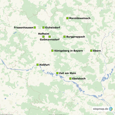
| − | <script type='text/javascript' src='http://www.stepmap.de/js/stepmapexport.js'></script> | + | [[Königsberg in Bayern]] |
| − | <div style='height:640px;'><div style='position:absolute;'><img src='http://www.stepmap.de/getmapimg.php?id=1259310&w=640&m=2&embed=27fe0fa0b39bd3646dfc7a457e0ea4c619ea5df4' width='640' border='0' alt='Landkreis Haßberge' usemap='#stepmapexportimg1259310_640' /><br />Eigene <a href='http://www.stepmap.de/landkarte-italien' target='_blank'>Landkarten von Italien</a> auf stepmap.de erstellen<br /> <map name='stepmapexportimg1259310_640'><area shape='rect' coords='515,593,631,621' href='http://www.stepmap.de' alt='StepMap' title='StepMap' target='_blank' /> <script type='text/javascript' src='http://www.stepmap.de/getmapjs2.php?id=1259310&w=640'></script> <area shape='rect' coords='0,0,640,640' href='http://www.stepmap.de/karte/landkreis-hassberge-1259310' alt='Landkreis Haßberge' title='Landkreis Haßberge' target='_blank' /></map></div></div><br /><br />
| + | [[Zeil am Main]] |
| | + | [[Ebelsbach]] |
| | + | [[Friesenhausen]] |
| | + | [[Haßfurt]] |
| | + | [[Ebern]] |
| | + | [[Burgpreppach]] |
| | + | [[Goßmannsdorf]] |
| | + | [[Hofheim]] |
| | + | [[Eichelsdorf]] |
| | + | [[Maroldsweisach]] |
| | + | |
| | + | |
| | + | |
| | + | |
| | + | <imagemap> |
| | + | Bild:Stepmap-karte-landkreis-hassberge-1259310.jpg|400px |
| | + | |
| | + | circle 837 1440 20 [[Haßfurt]] |
| | + | |
| | + | circle 1168 1127 20 [[Königsberg in Bayern]] |
| | + | |
| | + | circle 1276 1628 20 [[Zeil am Main]] |
| | + | |
| | + | circle 1566 1750 20 [[Ebelsbach]] |
| | + | |
| | + | circle 2032 1124 20 [[Ebern]] |
| | + | |
| | + | circle 967 814 20 [[Hofheim]] |
| | + | |
| | + | circle 1103 815 20 [[Goßmannsdorf]] |
| | + | |
| | + | circle 1434 813 20 [[Burgpreppach]] |
| | + | |
| | + | circle 773 613 20 [[Friesenhausen]] |
| | + | |
| | + | circle 968 608 20 [[Eichelsdorf]] |
| | + | |
| | + | circle 1499 403 20 [[Maroldsweisach]] |
| | + | |
| | + | |
| | + | |
| | + | desc bottom-left |
| | + | </imagemap> |